Hurricane Ida

Help Support CattleToday:

Prayers and safe thoughts to all who will be in the path of the worst of it, near the coast and landfall area.....up into the couple of states it will hit before it loses some of it's wind and fury....
We are in the path for it with rain... it is supposed to make a fairly sharp turn and head out almost due East towards the coast after getting up this far inland.... I just hope we do get some of the rain.... We have been missed by more of the storms/pop ups than anyone I know. Tonight I was coming home from milk testing and it started raining at the house as I finished the computer work.... drove 30 miles south through areas of several trees down across 1 or 2 lanes of Route 11 which is a major north/south route that "came before" Interstate 81.... and then drove right out of it.... Went another 8 miles to the house and got the milk samples inside then got a decent shower... all sorts of thunder and lightning.... then it stopped... can see the really bright lightning to the east... now getting a bit of an extended area that stuck around, I guess, as it was forecast to exit the area...getting a nice rain for a few minutes... We could use some more rain but sure don't want the 5-15 inches forecast for different areas. 2-3 inches would be nice.
 
Appreciate the invite, but at this point I like my place better than I-10. By tomorrow morning they will be running out of gas and patience. You will need a translator to get anywhere. lol
I made that I-10 west drive from New Iberia to Baytown Tx ahead of Hurricane Andrew when it made it's 2nd landfall, at Morgan City. 1992 I think.
It was not fun.

Looks like the track has shifted a little East. Might help you some.
 
Last edited:
Hitting this evening isn't she?
I believe that has been the forecast for some time now, tho with a major hurricane, the wind fields are so large that 'hitting' (landfall) has not a very precise definition. Especially true on the NE quadrant.
Traditionally, landfall meant the time/date the eye crossed the coastline. Travelling at 13-14-15mph, parishes to the East-NE can have been under hurricane force winds for hours on end and those on the NW and West side receiving at least tropical storm force winds for the same period of time, as well as the torrential rainfall.
 
I was driving to Chawlstun SC 16 years ago when Katrina landed. It made for an interesting trip back home with trailer in tow.
 
16 years ago, today, Katrina made landfall in Louisiana.
Remember it well as a lot of those folks were sent all over the country. Kentucky took in several to house and not long after they were getting in trouble. I had first hand experience working with a couple of Juveniles from there.
 
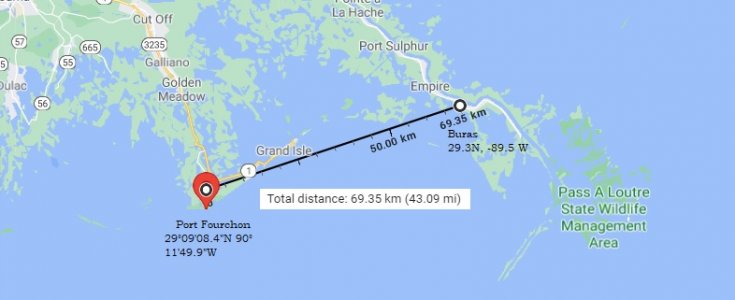
Weatherdotcom says landfall was at Port Fourchon La. That is very close to where Katrina made landfall at Buras La 16 years ago to the day. I've worked at Port Fourchon decades ago and on a clear night, you can see the lights of Buras across to the East.

idakatdistance.jpg


What are the odds SonofButch?
(Or, has someone stolen the Bush Hurricane machine and set it on a 16 year cycle?
 

Latest posts

Top